Reko Diq copper–gold alteration map
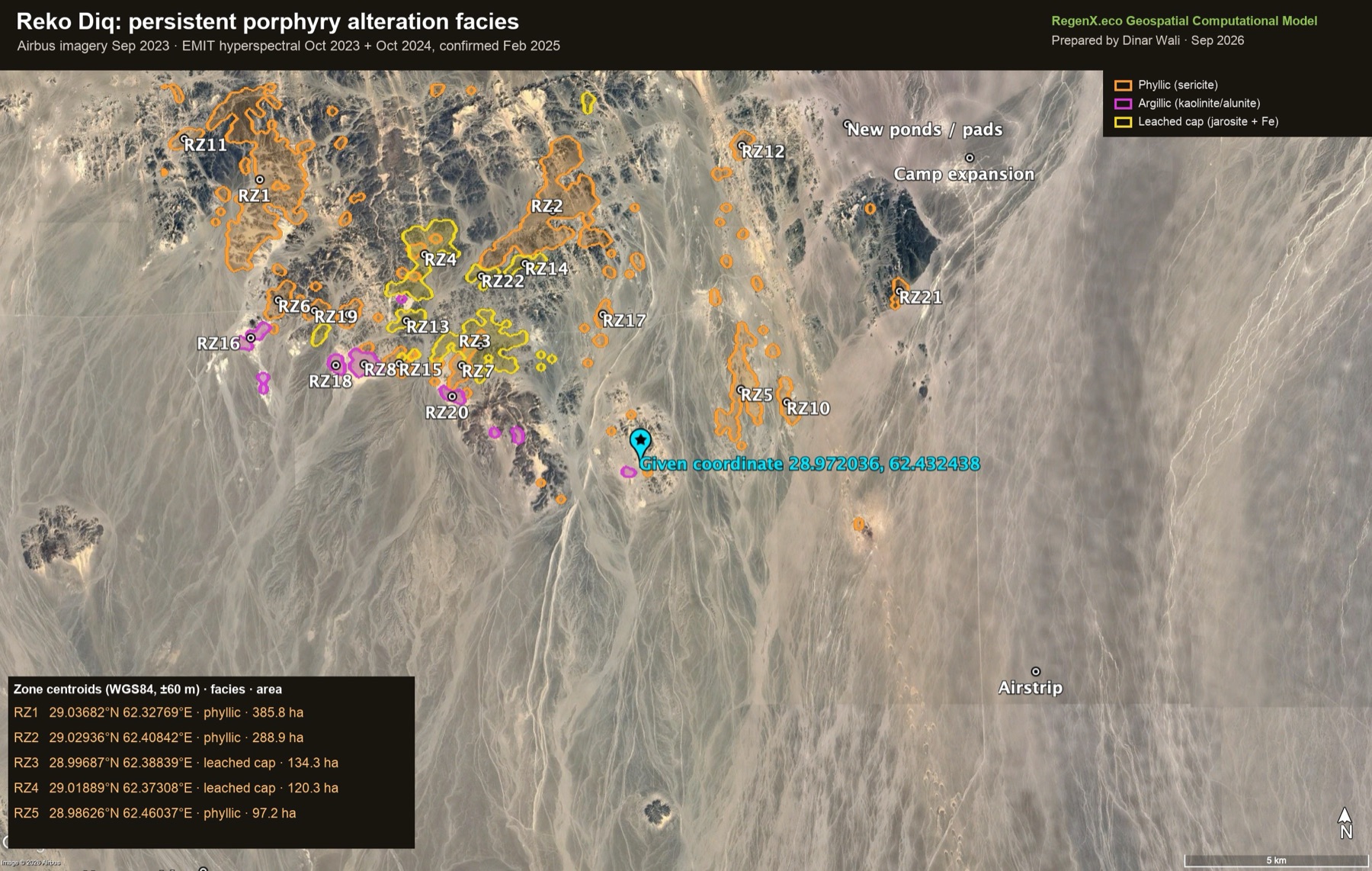
Satellite mapping of the porphyry alteration footprint at Reko Diq, one of the world's largest undeveloped copper–gold deposits. It uses NASA EMIT hyperspectral data on four dates, ASTER, Sentinel-2, Landsat back to 1990, and Google Earth Pro imagery from 2003 to 2026.
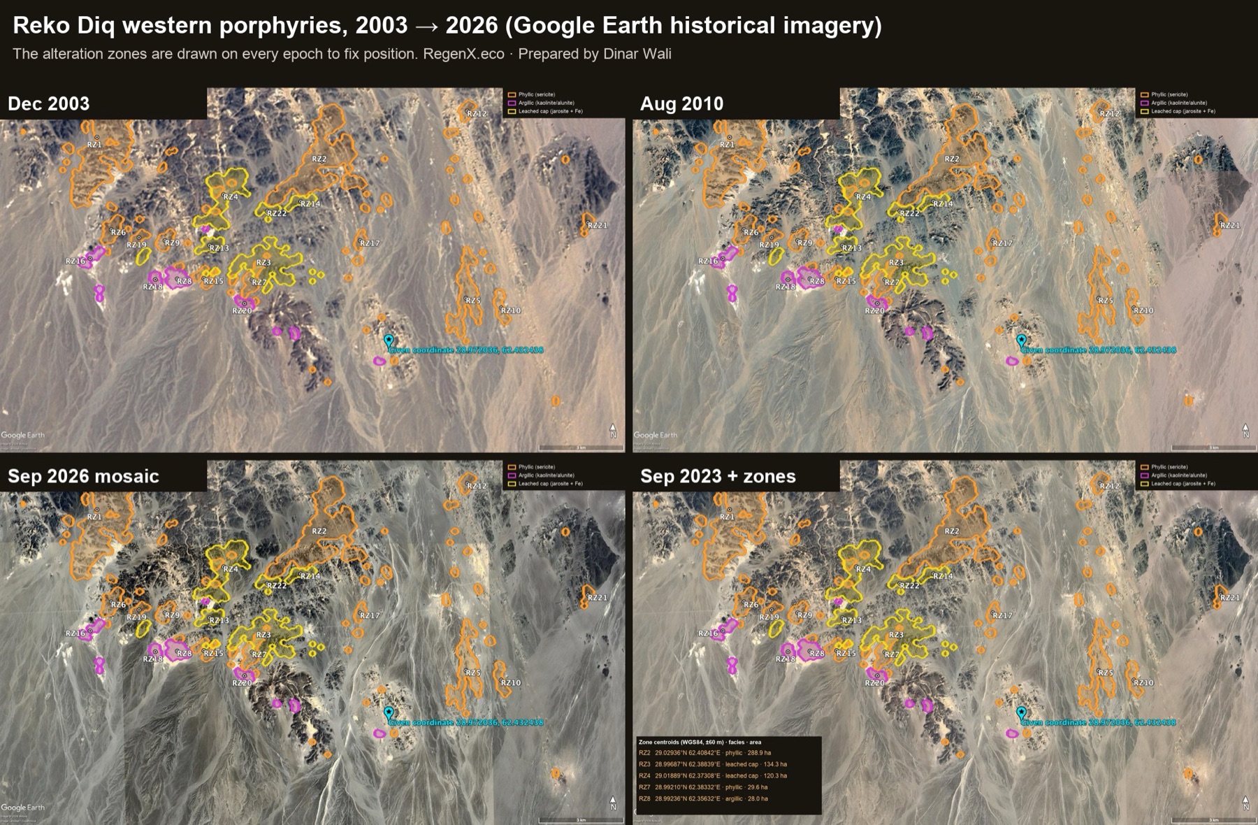
1 · Google Earth Pro imagery, annotated
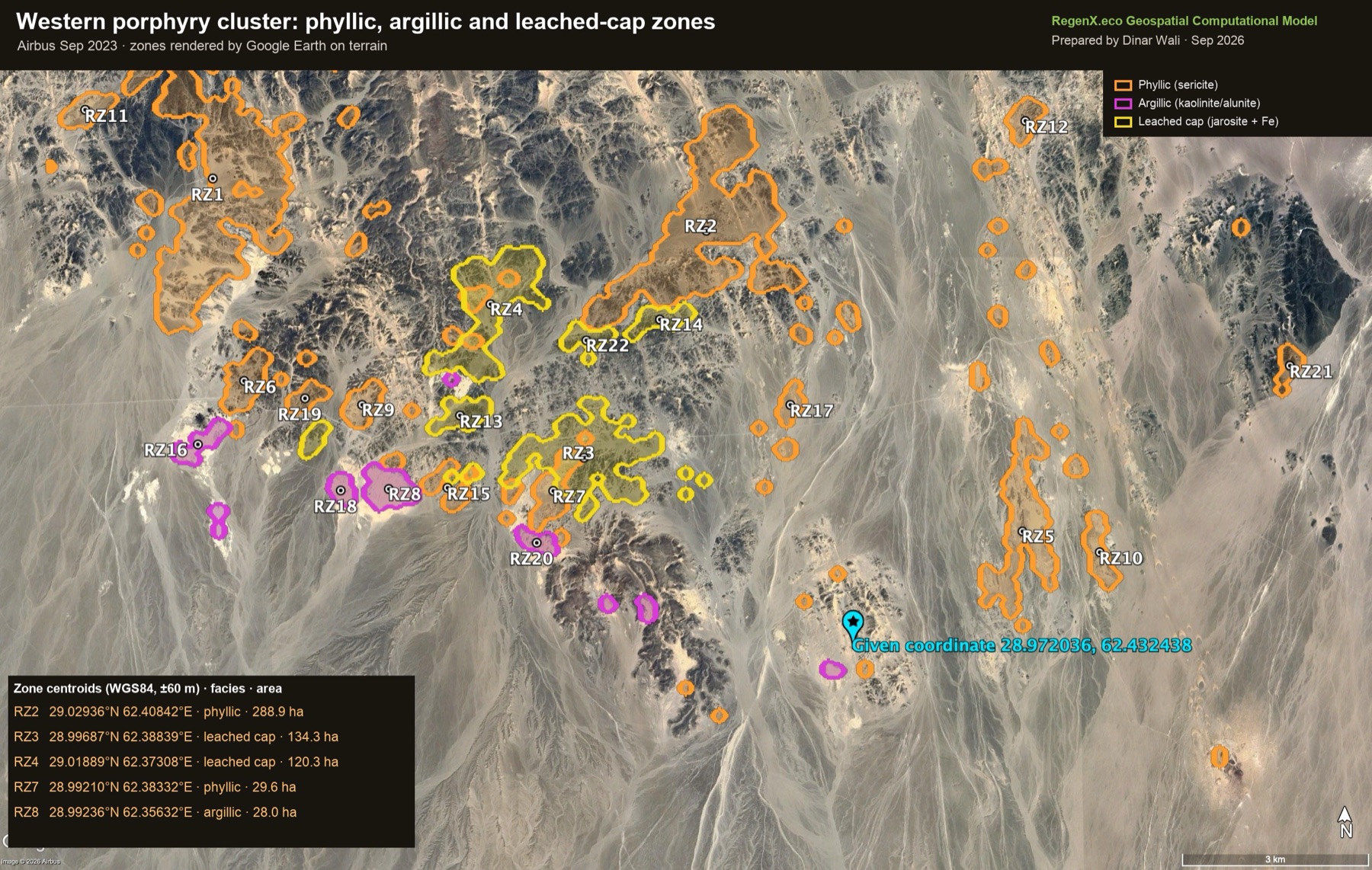
The alteration zones were loaded into Google Earth Pro as a KML and rendered by Earth itself on the Airbus imagery of September 2023, so every outline follows the terrain. The given coordinate 28.972036°N 62.432438°E sits on a low pale hill cluster on the eastern side of the alteration field.
2 · Historical imagery, 2003–2026
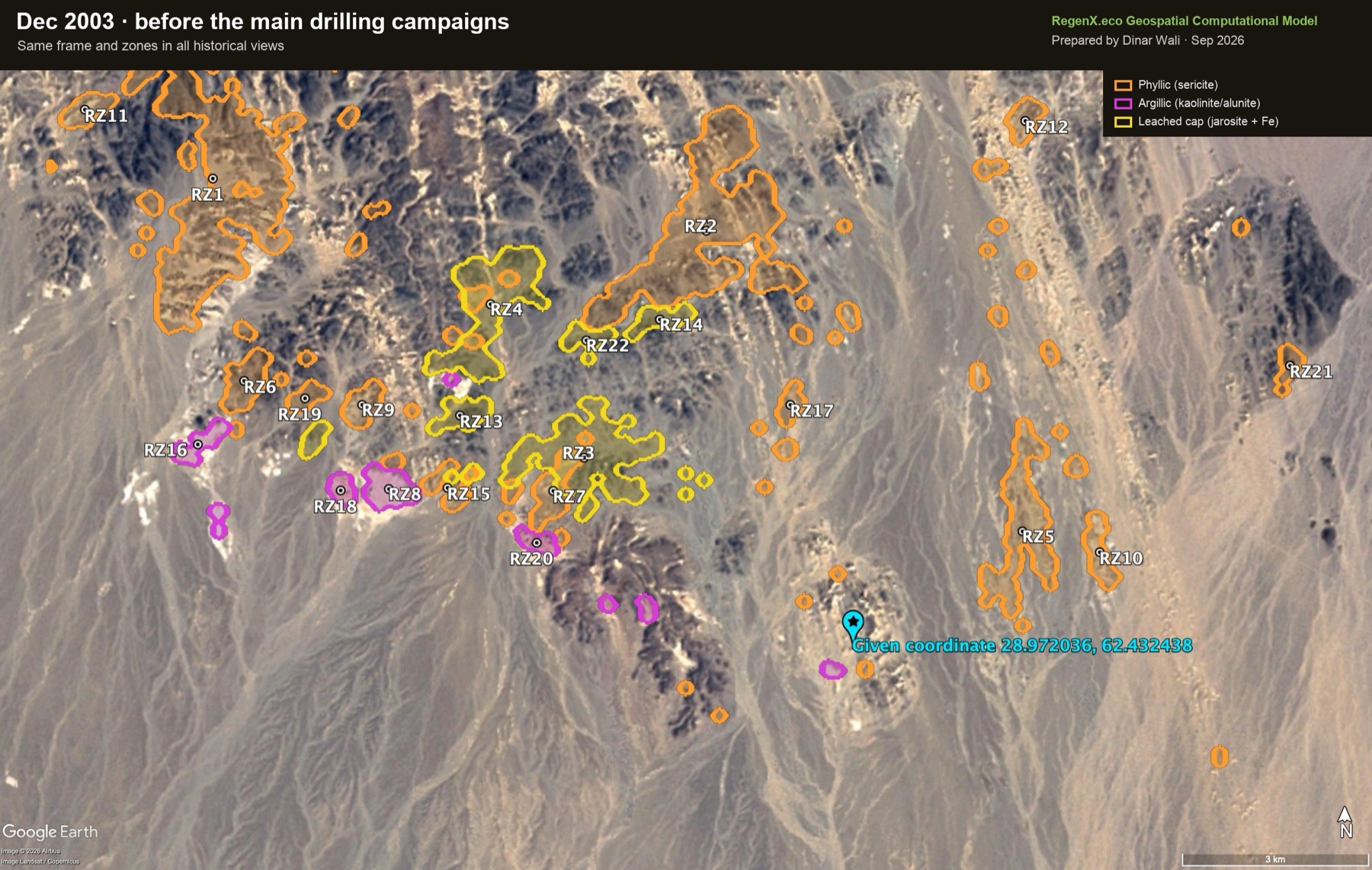
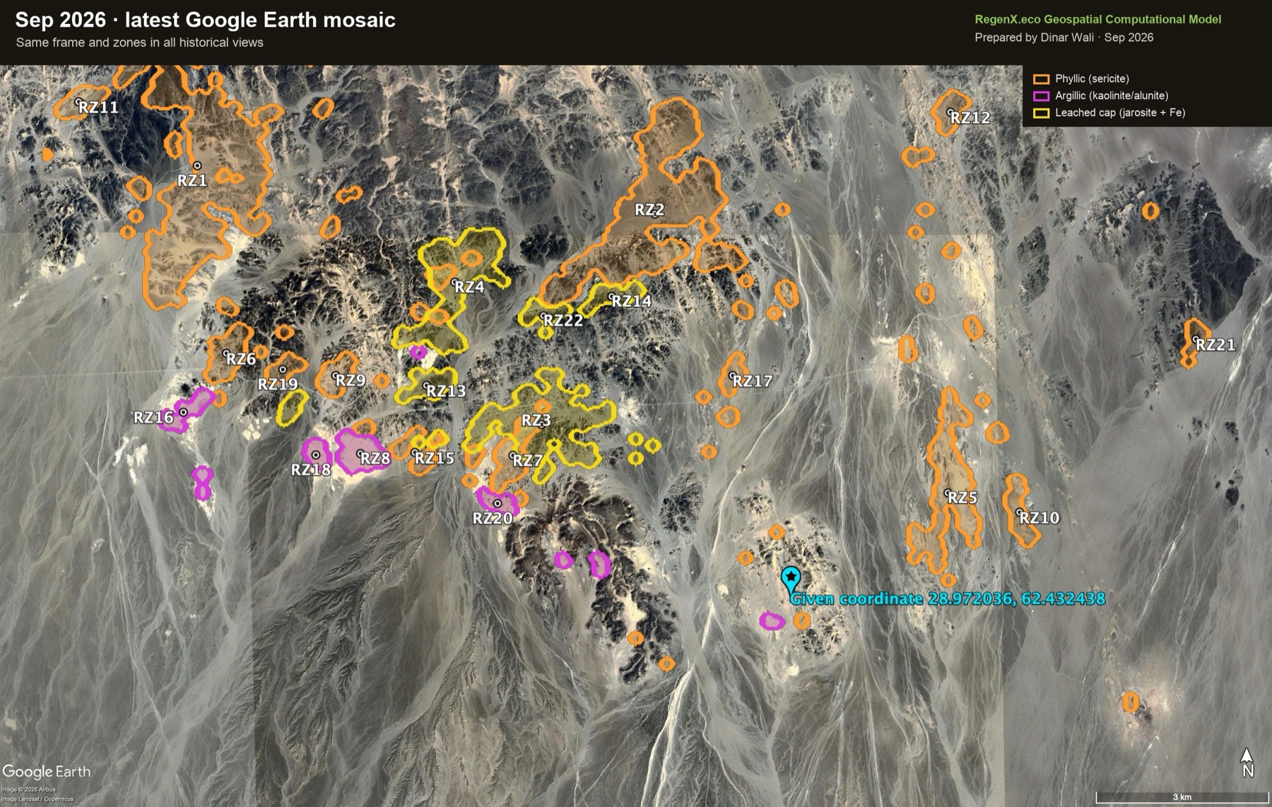 Dec 2003Sep 2026
3 · Ranked alteration zones
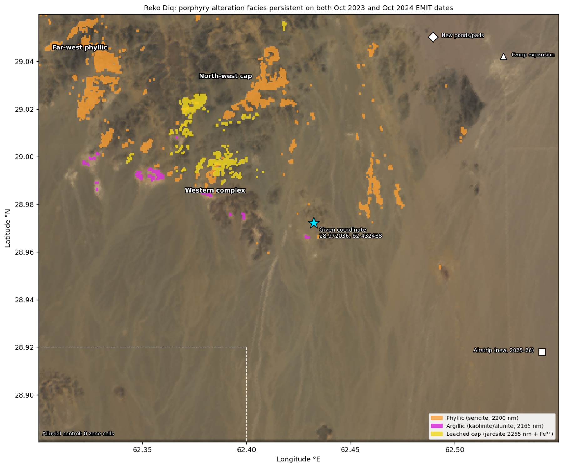
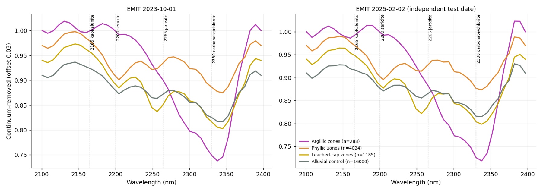
A cell joins a facies when its absorption is at least 2.5 robust standard deviations above the scene on both the October 2023 and October 2024 EMIT dates. The 2165 nm band marks kaolinite/alunite, 2200 nm sericite, and 2265 nm jarosite plus a ferric-iron band. Coordinates are WGS84 centroids, accurate to about ±60 m. Zones of 5 ha or more are listed.
| Lat °N | Lon °E |
|---|
4 · Spectral evidence
5 · Validation
| Test | Result |
|---|---|
| Alluvial control | 0 of 16,000 control cells meet any facies rule. |
| Independent date (2 Feb 2025) | Phyllic 87.4% of zone cells exceed z 2.5 again (control 0.21%). Argillic 81.2% (0.24%). Leached cap 78.7% (0.31%). Median z inside zones 3.4–4.5, against −0.15 to +0.16 on the control. |
| ASTER SWIR, 2000–2003 (3 scenes) | A different sensor 20 years earlier: argillic zones show ASTER kaolinite index z +5.4, and phyllic zones ASTER Al-OH z +0.9. The leached cap is not separable in ASTER's broad bands. One 2003 scene was rejected for a clipped band. |
| EMIT's own mineral library (12 dates) | Jarosite is identified in the same cells on 3 or more dates 39× more often than chance (1,703 vs 43). Kaolinite and alunite labels never appear in the library output, even where the band depths are strong, so the band-depth method is used for those. |
| Coverage | Retrievals on about 100% of pixels on 11 of 12 dates. It is a hyper-arid desert with no snow and almost no vegetation. |
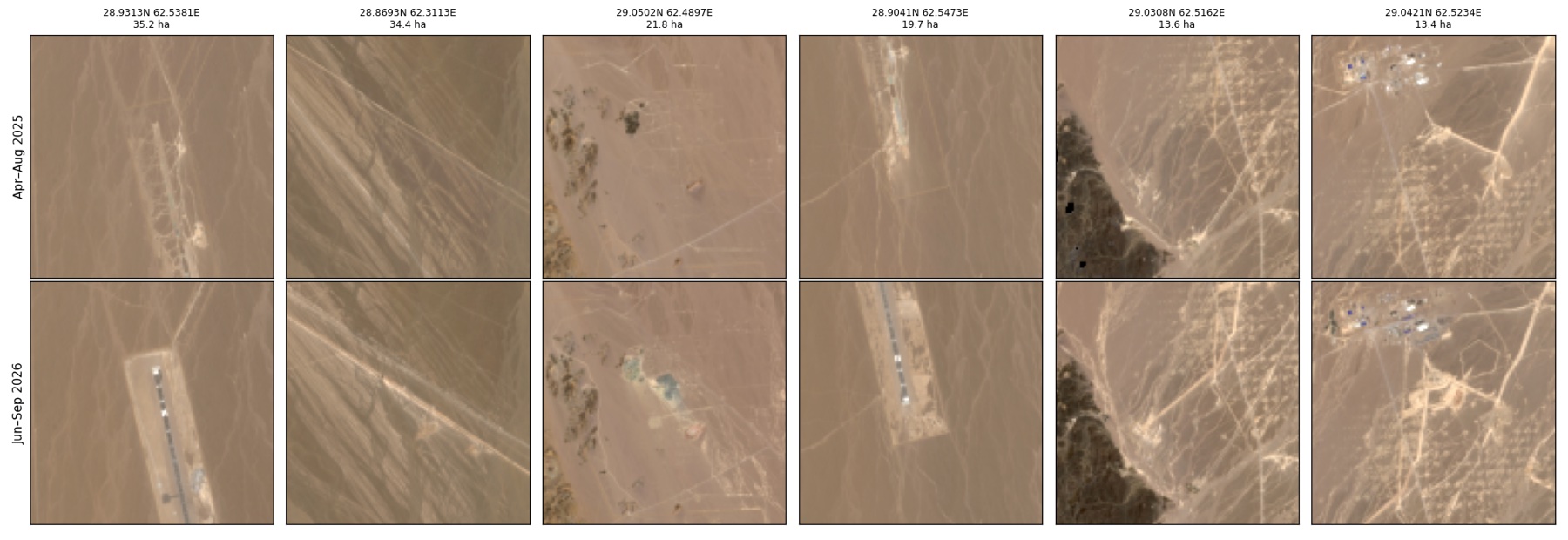
6 · Construction activity, 2025–26
| Feature | Lat °N | Lon °E | Area ha |
|---|---|---|---|
| Airstrip (north part) | 28.93132 | 62.53812 | 35.2 |
| Airstrip (south part) | 28.90409 | 62.54728 | 19.7 |
| New corridor | 28.86927 | 62.31129 | 34.4 |
| New ponds / pads | 29.05021 | 62.48972 | 21.8 |
| Camp expansion | 29.04206 | 62.52336 | 13.4 |
Landsat from 1990 to 2026 shows the long exploration history. Around the given point, 3–5% of the ground changes brightness in any given epoch against the 2020 baseline, compared with 0.2–0.4% on the control plain.
7 · Context
Reko Diq lies in the Chagai magmatic arc. Mining is planned in two areas. The Western Porphyries pit takes in the H79, H15, H14 and H13 deposits, dated about 12–13 Ma. The Tanjeel pit, about 4 km east, exploits the older H4 centre (about 22–23 Ma). The global resource is reported as 5.9 billion tonnes at 0.41% Cu and 0.22 g/t Au. Barrick's 2025 feasibility study projects 13.1 Mt of copper and 17.9 Moz of gold over a 37-year life. Barrick holds 50%, three Pakistani state enterprises 25%, and the Government of Balochistan 25%. Barrick reports 15 porphyry surface expressions in the lease, 5 of them in the current plan.
The alteration field mapped here runs mostly west and north-west of the given coordinate, consistent with the Western Porphyries. Matching individual zones to named deposits needs the company's deposit map, which is not public in a georeferenced form.
8 · Method and limits
Data.
- NASA EMIT L2B mineral ID (12 dates, 2022–2024).
- EMIT L2A reflectance: 1 Oct 2023, 1 Oct 2024 and 2 Feb 2025, plus 5 Apr 2023 at partial coverage.
- ASTER AST_07XT (2000–2003).
- Sentinel-2 L2A: 14 scenes, April 2025 – September 2026, tile 41RMN.
- Landsat 5, 7, 8 and 9 (1990–2026).
- Copernicus GLO-30.
- Google Earth Pro, Maxar and Airbus imagery: December 2003, April 2004, August and November 2010, September 2023 and the September 2026 mosaic.
Rules carried over from Bayan Obo, Hatoun and Chitral. A result must repeat across dates, stay clean on control ground and survive an independent test date. A second sensor must confirm it, and Earth-rendered annotation must show it on real terrain.
Limits.
- EMIT pixels are 60 m.
- Copper minerals themselves are not detected.
- Drill pads and tracks can brighten the surface locally.
- The given coordinate lies in a modest part of the alteration field, not at its peak.
- Nothing here is an assay or a resource estimate.
Contact
I build geospatial computational models that measure what the ground is actually doing. I founded RegenX.eco in 2023 to turn open satellite archives into evidence that governments, lenders and developers can act on. We have applied the model to more than 30 sites across Pakistan, the UAE, Nepal and China, and every number ships with its formula, inputs and limits.
dinar.wali@regenx.ecoSources
- Barrick 2024 reserves release (6 Feb 2025) and Dawn on the updated feasibility study.
- International Mining: Western Porphyries and Tanjeel pits.
- Temporal evolution of the Western Porphyry Cu-Au systems at Reko Diq, Economic Geology 109(7). Abstract only.
- Razique et al., Magmatic evolution of the H14–H15 deposit. Abstract only.
- Download the alteration KML for Google Earth · Code and data on GitHub
- Data: NASA EMIT and ASTER (LP DAAC), Copernicus Sentinel-2 and GLO-30, USGS Landsat. Google Earth Pro imagery © Airbus and Maxar Technologies.